
We have been visiting megalithic sites for over twenty years now, and our recording methods and materials have improved vastly over this time. The techniques shown below are those we have used to record most of the recent images in this site, but we are currently developing new ideas.
Photographic Equipment.
All conventional 35mm work was
with Canon equipment, lenses 7.5mm to 500mm.
An Horizon 202 panoramic camera was also used, this is a 35mm swing-lens
camera, it has a 28mm lens yielding a 120 degree angle of view.
Medium format work was in 6x7cm using Pentax 67MkII bodies, lenses 35mm to
200mm.
Large format work was in 4"x5" with CamboWide and MPP field
cameras. Lenses were by Schneider, 58mm XL to 210mm, centre filters were
used on all wide angle lenses.
Spherical and annular 360 degree
panoramas and partial
panoramas were stitched from 35mm SLR portrait oriented frames, or from
Horizon frames, using LivePicture Photovista or Helmut Dersch's excellent Panorama Tools
software.
All panoramas were taken using homemade nodal point rotation mounts.
35mm infra red photographs were taken with Canon bodies adapted with an 87C filter mounted between the film rails, or with the Horizon using a homemade 87C filter fitted in front of the lens. 6x7cm and 4x5 exposures used a conventional before-the-lens 87C filter.
From 2004 some infrared shots were taken using a Sony F717 digital camera which we have internally modified to allow true infrared function. The modified F717 was used at ISO100 with homemade 88A and 87C before-the-lens filters. From Jan 2008 a Fuji IS-1 was also used.
Film scanning was via Nikon Coolscan LS2000, 4000ED and Agfa Vision 35 for 35mm, and Agfa Duoscan T2500 for medium and large format.
DSLRs were by Canon, lenses 8mm to 500mm (35mm equivalent).
Film
Colour negative film was Kodak
Royal Gold 25, until they withdrew it (sob, sob) :-(
Latterly, Konica Impresa 50, and Fuji Reala 100 were used.
Transparency film was Fuji Velvia (35mm, 6x7cm and 4x5).
Infra red film was Kodak High Speed Infra Red emulsion, HIE (35mm), Aerographic (6x7cm), and HSI (4x5). Development was in Xtol.
Conventional monochrome film was Kodak Technical Pan, developed in Technidol.
Colour Calibration
Images were prepared using PCs
and sRGB IEC61966-2.1 working colour space. Monitors were by Viewsonic,
21" aperture grille Sonictron CRTs and 20" high contrast flat
panel displays. Monitors were instrument calibrated to a gamma of 2.2 and
a 6500K white point, they were then ICC profiled using ColorBlind Matchbox
and a screen colorimeter.
Site visitors using Macs will probably have their monitors calibrated to a
gamma of 1.8 and our images will appear slightly too light with perhaps
some highlight loss.
Position Measurements
Our default coordinate system is Ordnance Survey (OS) as most of work was done in the UK and these are the most likely maps anyone will be using for UK monuments. All quality GPS devices will also accept OS references.
As anyone who has visited a lot of megalithic sites will know, they are not always where the OS maps show them to be!
Map references quoted as being measured by us were taken using a Garmin GPSIII Global Positioning System (GPS), satellite receiver (firmware revision V2.06 or 2.10).
From December 2007 a Garmin GPSMap 76Cx was used, firmware revisions V2.5 to V4.00.
Measurements in the UK were
taken using British Grid Position Format and the OSGB Map Datum.
Measurements in Ireland (both bits), were taken using Irish Grid Position Format and
the Ireland 1965 Map Datum.
Measurements in countries with no GPS accessible grid system were taken
using Lat/Long and WGS84 Map Datum.
The GPSIII is not differential, and was therefore subject to error introduced by the USAF Selective Availability (SA), program. The map references taken by us therefore divide into two levels of accuracy, SA and non-SA measurements.
Non-SA Measurements (2-4m error)
Map references measured by us after 01/05/00 without SA are shown in blue.
SA was finally discontinued on the first of May 2000 :-) This gave an immediate accuracy boost to all GPS measurements. The main error factor in non-SA GPS measurements is atmospheric distortion of the GPS signals and multipath, under typical conditions this imposes a maximum positional error of about 10m, this effect can be reduced by multichannel measurement and averaging. The next error threshold is clock error, this causes a spot measurement uncertainty of about 4m.
The graph below shows the actual effect of averaging duration on the accuracy of a Garmin GPSIII receiver (the 76Cx will be at least as good), the sampling interval was 2 sec. As can be seen, after only 15min the error is down to the 3m level. These figures are for "open sky" sites, heavy foliage or uneven topography will reduce accuracy by degrading or blocking some of the satellite signals.
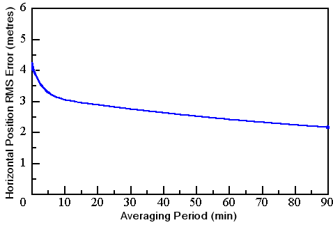
The GPSIII is capable of multi-tracking 12 satellites simultaneously, and we will continue to average over time at the sites, but the above graph shows the irreducible error inevitable with our equipment.
Measurements with SA (13-100m! error)
SA was in operation during all measurements prior to 01/05/00, map references quoted as being measured by us before this date are shown in yellow.
When it was in operation, SA error was quoted as being within 100m for 95% of the time, this could be substantially reduced by averaging the GPS readings at a site over time. When a map reference measured by us is quoted, the averaging time is also shown. The following table shows the 99.9% values expected for various averaging times with SA in operation.
30min. 36m
1Hour 19.2m
2Hours 13m
4hours 8.9m
A comparison of these figures with the Non-SA graph above will reveal why we were really over the moon when SA was finally given the push - thanks Bill!
Orientation and Dimensions
When present in a panorama, the ranging pole (2m), is positioned at true south from the circle "centre". Bearings were taken with a Suunto KB-14D sighting compass readable to half a degree, local magnetic variation was allowed for. We've been asked several times why we use a South reference and not North. As far as we know, none of the megalithic monuments we deal with have commonly occurring North alignments, but many monuments in Scotland such as Recumbent Stone Circles and Clava sites (ie. our favourites) have well-documented strong SSW and SW alignments, so that is why.
Panoramas (and GPS measurements), were usually taken from the "centre" of stone circles and circular features. Many "circles" are not truly circular, also, our measured diameters sometimes varied quite considerably from published figures. Our rough and ready centering method was to measure several diameters from stones still standing, and make a "best guess".
In cases where only a few, or no stones were still standing, the centre was estimated using published diameters. In recumbent circles where only the recumbent remains, the centre was guessed by using published radius perpendicular to the recumbent, if it appeared to be in its original orientation.
Circle diameters quoted by us are averages of distances measured from the inside face of opposing stones where possible.
We have recently (2002), changed the way we measure circle diameters, measurements are now taken from the centre of stones as this will be closer to the diameter of a "best fit" circle derived from a plan drawing of the ring. Diameters measured in this way have a "SC" after "Meas." on the site mainpage.
Magnetic Anomalies
We began checking circle stones for magnetic anomalies starting with our last Aberdeenshire trip. The test is very crude, basically, a compass was passed over the faces of each stone and around the stone at three heights (if Keith could reach that far). OK, it's not exactly flux gate, but at least we're trying :-)