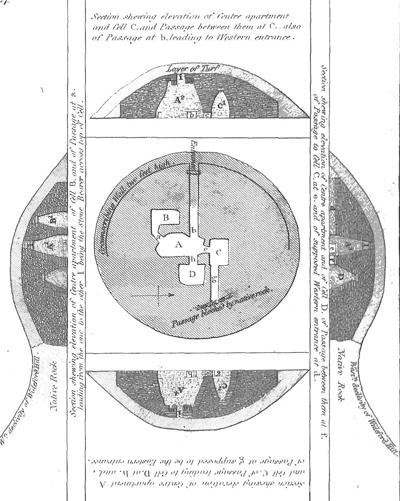
"Archaeologia, 34, p.136, pl.15, 1852

This is Thomas' original
plan of Wideford Hill, he travelled to Orkney on the Royal Navy survey ship
"Woodlark" in 1850. His paper
including the plan was "read" by the Society of Antiquaries of London in 1851.
Petrie had opened the cairn in autumn 1849 and had
discussed his findings and assumptions with Thomas.
The diagram agrees well with modern plans and notably shows the curious
"chimney" structure in the centre of the roof of the main chamber.
Unfortunately this structure has been destroyed and the cairn is presently
entered by a ladder through the void in its previous location. Another notable
feature
of the plan is the passage leading east from the northern side-chamber, Petrie
thought that this may have been an eastern entrance passage to the cairn.
In a letter to Thomas he describes a later investigation of this feature "The
passage to the eastward appears never to have been completed, as it only
extends for six or eight feet, and then terminates."
Daniel Wilson
The Archaeology and
Prehistoric Annals of Scotland, Sutherland and Knox, 1851, Edinburgh

Wilson describes this
diagram as "plans engraved, drawn from careful measurements taken at the time"
that he received from Petrie along with
notes on his excavation. Because of the obvious similarities to Thomas' original
plan we suspect this is a second more attractive version done for publication
in Wilson's book. It was probably also by Thomas as the accompanying text
reads "drawn by Lieu.F.W.L.Thomas R.N. from Plans by George Petrie, Esq.",
although several legends referred to in the book are missing in this version,
most notably that for "stone m", by which entry into the main chamber was
made.
The possible passage to the east from the northern side-chamber is shown
considerably larger, perhaps reflecting Petrie's further investigations and
later communications with Thomas.