|
|
|
|
More Photos |
||
|
|
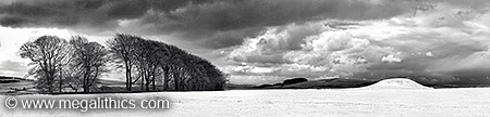
Panoramas |
||||
|
|
Infrared |
||||
|
|
Antiquarian |
||||
|
|
| SK 16034 63561 (GPS 11min) cove. | Bank diameter (crest) 75-79m, circle diameter c. 37-42m (pub.) |
| Visited April 2010 | Altitude 373m OD (GPS) centre. |
The stone numbering used in this account is that of Barnatt (8)
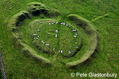
Arbor Low is an impressive henge monument
in Derbyshire, known as the "Stonehenge of the North" it is situated in farm land around 7.5km SW of Bakewell.
The scale of the monument is overwhelming to the visitor, and by its very
nature, can really only be fully taken in when viewed from the air.
The henge is built on a hillside and therefore the site is not level having a
pronounced slope to the NW, we measured the elevation of the henge centre at
373m (averaged GPS). The name Arbor Low is derived from the Anglo-Saxon name "Eorthburg
Hlaw", which simply means "earthwork hill", Arbe Low and Arbelows
are often mentioned in antiquarian texts as alternative local names for the monument.
A second large henge
monument, The Bull Ring, can be found only 16.5km to the NNW at Dove Holes, although this
now lacks the internal
stone circle and cove found at Arbor Low.
Such a large, obvious monument must always
have been known locally but the earliest published accounts such as those of
Pegge
(1) and Pilikington
(2)appear in the 18th century. Pegge's
illustrations and plan agree reasonably well with modern examples, but the stone
count and positions on Pilkington's plan are very inaccurate. The 19th
 century saw more accounts of the
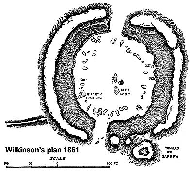
monument being published, Wilkinson
(3) produced a very accurate plan of the henge
(see left and our antiquarian page), this compares well with the modern plan of the
monument above. While describing the stones of the central circle, Wilkinson
mentions "that a very old man, living in Middleton, remembers, when he was a
boy, to have seen them, standing obliquely on one end.". Glover's account of
1831
(4) includes a map drawn by Samuel Mitchel and he repeats
Pilkington's account of the old man seeing the stones erect but adds "This
secondary kind of evidence does not seem entitled to much credit" . Glover also
dismisses a commonly held theory at the time that the henge was a centre of solar-worship, with the radial
positions of the stones intended to portray the rays of the sun.
century saw more accounts of the
monument being published, Wilkinson
(3) produced a very accurate plan of the henge
(see left and our antiquarian page), this compares well with the modern plan of the
monument above. While describing the stones of the central circle, Wilkinson
mentions "that a very old man, living in Middleton, remembers, when he was a
boy, to have seen them, standing obliquely on one end.". Glover's account of
1831
(4) includes a map drawn by Samuel Mitchel and he repeats
Pilkington's account of the old man seeing the stones erect but adds "This
secondary kind of evidence does not seem entitled to much credit" . Glover also
dismisses a commonly held theory at the time that the henge was a centre of solar-worship, with the radial
positions of the stones intended to portray the rays of the sun.
Glover neatly sums up the limited scope of his and other previous accounts of the monuments, "it will be our business to describe them and leave their critical examination to others.". Bateman (5) (6) however, was an altogether more hands-on investigator, and led several "excavations" into the monument, eventually discovering the cist contained in the round barrow which was a latter addition to the henge.
The only modern excavations at Arbor Low were by Gray (7) in 1901-2, these investigations were mainly directed at the bank and ditch, although one circle stone and the central area near the cove were given some attention. For a modern account of Arbor Low, we recommend Barnatt's (8) excellent work on the Peak District's henges, cairns and circles.
As the stone circle may have been erected at a different time to the building of the henge (Gray noticed the circle's limestone was a different colour to that from the ditch), there may actually be three separate monuments at Arbor Low, the henge, the stone circle, and the round barrow constructed on the bank after the henge was built.
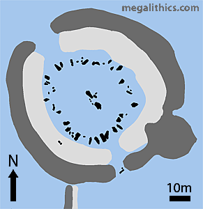
As with most monuments of this class the henge is differentiated from defensive earthworks by the location of the ditch inside the bank. The whole monument has an external diameter of around 87m with a total ground area of just under 6000 square metres.
The ditch width is not constant, on the east side it is between 9-12m, but only 7-9m on the west. The smooth rounded profile of the ditch today is due to silting, earth and debris have been blown and washed into the ditch over the millennia, reducing its depth and smoothing its contours. Gray was particularly interested in the ditch during his excavations of 1902-3, he dug six trenches through it and discovered that is was originally between 2m and 3m deep and had very steeply cut sides. He also discovered that the ditch was dug through rock, this is quite an achievement considering the builders had only antlers to use as picks.
Two unquarried areas at the NW and SSE form causeways to serve as entrances to the central area. The NW entrance, at 9m, is much wider than the 6m SSE entrance and this may reflect their importance to the original users. The SSE entrance has the stump of a stone set radially, a large fallen stone lying close to this may be its broken top, if so, the stone would have stood around 2.6m high. Portal stones have been found at other circle-henges, and it is likely that this stone was one of a pair, a 2m diameter pit in the NW entrance may be evidence for the existence of portal stones at that location also.
The bank top is almost circular with a diameter of 75-79m, today it stands on average about 8-10m wide and 2.1m high, but it is thought to have been about 3m tall when built. The only evidence we have for the composition of the bank is from two trenches cut either side of the NW entrance by Gray. He found the western bank was mostly composed of limestone rubble and to the east, of limestone boulders up to 4 feet long. As these materials were presumably produced by the excavation of the ditch, perhaps their differing natures reflect differing strata, or different extraction techniques. At least 7 trenches had been put into the bank before Gray's work, but no record of the excavations that produced them exists today, although Gray considered Bateman a likely culprit.
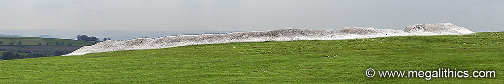
It is easy to visit henges today and see them as smooth grassy rings, but when Arbor Low was built, and for some considerable time afterward, the exposed limestone of the bank up on the hillside would have been a striking, almost white, expanse visible for many miles (forestation allowing). The illustration below is what the henge might look like today with its layer of grass and earth stripped away, it would have been even more striking when just built as the bank was at least a third higher.
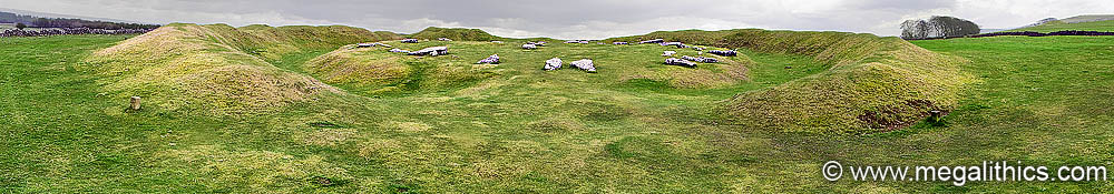
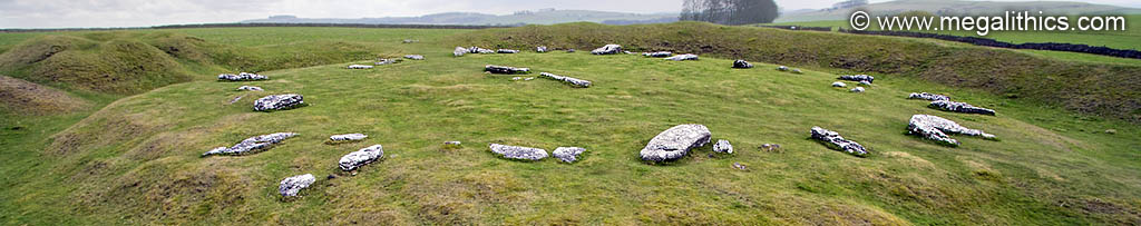
The central area enclosed by the ditch is oval in shape and varies between 40-52m in diameter, the edge of the NE quadrant being particularly irregular, perhaps due to excavation or erosion. The most impressive feature of this area is, of course, the array of large stones currently resting on it, the stone circle and cove.
This is comprised of around 50-52 large slabs and fragments on the central area distributed in a ring between 3-6m from the edge of the area, with one exception, all are fallen. Many of the large slabs ( particularly those in the southern quadrant ) lie with their long axes in a roughly radial orientation, hence the suggestions of a representation of the sun's rays forming a solar temple, which was dismissed by Glover. There were probably around 41-43 stones in the circle originally, and they appear to have been cut from limestone pavement, so they all show one side (originally that facing upwards in the pavement) with a more uneven weathered surface, in some cases solution holes penetrate the slabs all of the way through. From the stones for which original orientation can be determined, it appears that the slabs were mostly set with their uneven weathered sides facing inwards (8). The source of the slabs is uncertain, Gray observed that the colour of the limestone of the stones differed from that of the limestone he found in the quarried out ditch and speculated that the stones had been obtained from a more distant source, however no modern analyses have been performed to test this theory. In addition to the stones on the central area, two fragments have fallen into the ditch and now lie close together at the SW.
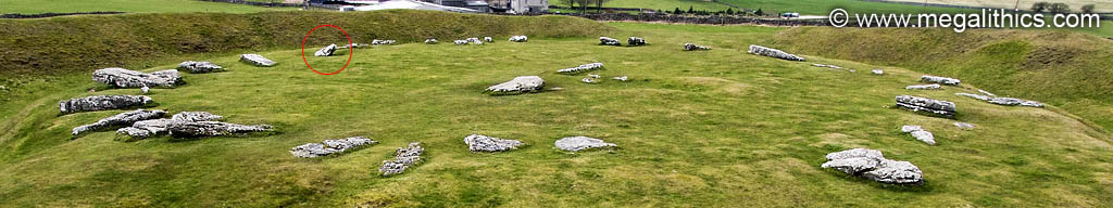
There has been much speculation in the past about whether the circle was ever originally erect, but all of the evidence points to this being so. In particular, several stones have snapped off at their bases leaving stumps in situ, seven of these can be reliably identified, and by chance they are well distributed around the circle, strongly suggesting a continuous ring of stones set circumferentially. Although all of the stones appear to be fallen, stone 31 (circled in the photo above) is actually still leaning, its top still some distance from the ground, stones 1,2,22 and 27 also have one end slightly above the ground.
Yet another area of controversy is whether or not the circle stones have been deliberately toppled, such as happened at the Avebury and Bryn Celli Ddu circle henges. The current belief is that the stones are the victims of shallow stone holes and weathering, there is nothing to suggest a concerted attempt at complete destruction. The circle has, however, been exploited as a source of stone for gateposts etc. by the local population, stone 35 has been split and bears a drill hole, there are also several wide gaps in the fallen ring suggesting purloined stones, and top sections cannot be found for four of the stumps mentioned above.
Despite the claims of Pilkington's witness, no stones are shown upright in any published plans, these start with Pegge in 1785. Stones were still being taken after this date, two fragments disappearing between then and 1824, but these were the last.
The original ring had a diameter varying between 37m - 42m, using an estimate of 75% of the stone length being exposed when erect, the average height of the stones was probably around 1.6 - 2.1m. Some sections of the circle had unusually tall stones, the area around the SSE entrance had 4 stones in the range 2.6 -2.9m, it is likely the NW entrance section was similarly emphasised. As tall as these stones were, none would have been visible to observers outside the henge except through the two entranceways, this restricted visibility was further modified by the construction of the central stone feature, the cove.
The cove stands at the centre of the site, in common with the surrounding circle, all of its stones are fallen. The cove was originally comprised of at least six stones, but two of these are gigantic, the NW example measuring 4.25m and the SW, 3.90m. The cove appears to have been a rectangular structure aligned with its long axis on a line through the two entrances, the two massive stones were placed at either end of this rectangle and therefore completely blocked sight of the cove interior by observers looking into the henge through the entranceway gaps. The SW side of the rectangle appears to have been formed by a row of much smaller stones, the stumps of three of these can be seen in our photo of this area. The NE side may have been open, two blocks lie beside the base of the large NW stone, but their original positions are uncertain. Gray excavated in several areas around the cove but failed to find stoneholes for the two massive stones, however, just to the south of the abovementioned two blocks on the NE side, he found a male skeleton surrounded by an oval setting of large blocks, the body was lying with the head to the SSE. Whatever its original form, the cove, with its carefully concealed interior, must have been a focus for ritual activity within the henge.
Most of the central area of the henge has never been excavated, Gray's examination of the cove area and one of the circle stones being the only documented investigation.
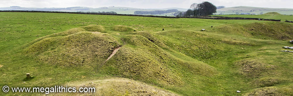
A large round barrow was built on the henge bank at the SE, given the reduction in the henge bank either side of the barrow it is likely that this was robbed to provide material for at least part of the barrow's construction. The mound is around 21m in diameter and is presently about 2.3m high, the original height is unknown as the barrow top has been dug into many times, resulting in the cratered appearance it has today (see photo baove). Because of the presumed use of bank material in its construction, the barrow is seen as a later monument superimposed upon the henge, but finds from the barrow complicate the situation somewhat.
Known excavations at the barrow began with the tenant farmer in 1770, little is known about this investigation, Rooke (9) excavated for five days in 1782 and "cleared away the whole centre of the mound" but found only antler tines. Bateman (5) followed in 1824 finding only animal bones and a human tooth, he tried again in May 1845 with much more success, he discovered a polygonal cist (6) just south of the barrow centre, this appeared to have been built on the old ground surface. The floor of the cist was made from three closely jointed limestone slabs, the side walls comprised ten edge-set slabs, and the cist cover was a single limestone slab measuring 3 feet by 5 feet. In the cist he found burned and scattered human bone, a bone pin, a flint, iron pyrites, a rim sherd and two pots. The classification of the pots is uncertain, originally taken to be unusual food vessels, Barnatt (8) mentions that they may be of Late Neolithic date.
As the cist was found on the old ground surface and contained pottery that may be of Late Neolithic origin, this rather complicates the notion that the barrow was a much later addition to the henge. Various ideas have been put forward to resolve this, one suggestion is that the cist was a primary burial in a mound that was contemporary or earlier than the henge bank and this mound was later expanded by robbing the bank, another suggestion is that the cist and pottery are of a later date, and were inserted by means of a shaft dug down through the henge bank when the round barrow was constructed.
Running away from the henge bank at the SSE is a low bank and ditch which curves slightly to the west. Known as "The Avenue" it was investigated by Gray who found that it terminated at the bank edge, showing that it was contemporary with or later than the bank. Gray found that the ditch had been rock-cut and was 0.9m deep and around 2.3m wide, he measured the much reduced bank at 3.7m wide, a considerable structure, obviously much concealed by erosion and silting today. Currently the avenue is not seen as part of the henge monument and is thought to be a much later field boundary.
In 1844 Bateman investigated a low barrow to the SE of the henge, measuring 10m x 11.5m it had already been disturbed and the rock-cut grave contained only fragment of iron. We could not make out any trace of this mound during our visit.
The most notable neighbour to the henge must be the massive barrow called Gib Hill. Standing only 300m away from Arbor Low at the NE, this monument must be considered to share the same ritual landscape as the giant henge. Currently an oval mound of 27m x 46m, Gib Hill is actually two monuments, echoing the barrow built on the henge bank at Arbor Low, a Bronze Age round barrow has been built on top of a neolithic oval, or long barrow. For more information visit our pages for Gib Hill itself (when we get around to them!).
We could not find any definite dating evidence ( certainly not any radiocarbon work ) for any of the phases of Arbor Low or Gib Hill, but English Heritage (2008) gives these, necessarily vague, datings.
4000 - 3000BC GIb Hill long barrow constructed.
3000 - 2000BC (perhaps around 2500BC) Arbor Low Henge built, the henge may have had a timber post circle at this time ( typological inference only, no direct evidence).
2500 - 2000BC Stone circle and other stone structures built in the henge centre, perhaps replacing timber post originals.
Around 2000BC Round barrow built on henge bank at the SE, round barrow built on top of original long barrow at Gib Hill. Up to three other very small barrows built close to the two monuments.
Both Arbor Low and Gib hill are open to the public, although on private ground. The site is signposted from the road and directs you up a farm track to a small car park, there is an honesty box for admission (£1 per person when we visited). The path to the henge passes through the farmyard and crosses two fields, the fields were pasture when we visited and are obviously grazed by livestock, access is via kissing gates. Gib Hill barrow is enclosed by a wire fence and access is via a stile. The kissing gates and stile will be a problem for wheelchair dependent disabled people. When we visited there were no facilities such as toilets available.
1.
Pegge Rev., Archaeologia, 7, p.131-148, 1785.
2.
Pilkington J., A View of the Present State of Derbyshire Vol.1, p.458-62,
J. Drewry, 1789, Derby.
3.
Wilkinson Sir G., The Reliquary, 1, p.156-166, 1861.
4.
Glover S., The History and Gazetteer of the County of Derby
Vol1., p.236-7, Henry Mozelly & Son, 1831, Derby.
5.
Bateman T., Vestiges of the Antiquities of Derbyshire,
p.109-11, John Russel Smith, 1848, London.
6.
Bateman T., Ten Years' Diggings in Celtic and Saxon Grave
Hills, p.283-4, J.R.Smith, 1861, London.
7. Gray St.G. H.,
Archaeologia, 58, p.461-98, 1903.
8. Barnatt J., The
Henges, Stone Circles and Ringcairns of the Peak District, University of
Sheffield, 1990.
9.
Rooke , Archaeologia, 6, p.110-115, 1782.