|
Photo Gallery |
|
Panoramas |
||
3D Vision |
||
| SX 63285 89613 (GPS 25min). | Dia. 20.5m (Meas. SC) |
| Visited June 2003 | No magnetic anomalies |
The most northerly of the great stone
circles of north eastern Dartmoor, White Moor Down circle is a sight to gladden
the heart of any megalithic enthusiast. The circle stands on desolate moorland about 7km WSW of Chagford and megalithically inclined visitors will
almost certainly chose a route to the circle from the north, so that a visit to
the stone rows at Cosdon can be made on the way. The journey is not for the
fainthearted, the approach is a 4.5km walk over rough moorland and the final
kilometre of the path skirts the Raybarrow Pool. The Pool is an area of
dangerous bog about 1km by 0.5km in extent and although the 1:25000 OS map shows
the that the footpath skirts the bog, we quickly found this was not true. So if
you plan a visit to this site, beware! especially if there have been recent
rains.
Up to the late 19th century the circle suffered at the hands of stone masons and
farmers, stones were reduced to stumps as their granite was taken to use as
gateposts and as simple raw material. Only 13 stones were visible at the site
when first described by Prowse (1) in 1890 and only 8 to 9 of these were
upright. In 1894 five more fallen stones were revealed when turf cutters removed
peat from the site, finally the circle was restored in 1896. After restoration
18 stones were visible but there were two obvious gaps, one at the east between
stones 5 and 6 and another at the NW between stones 16 and 17. A pit containing
stone fragments was found at the eastern position but no stonehole was found in
the NW gap, suggesting a ring of 19 stones originally with, perhaps, an entrance
at the NW. Accounts of the reconstruction are vague and it is not known which of
the stones have been re-erected.
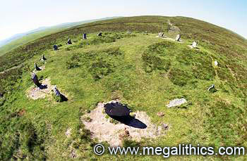
When we visited the site we found 18 stones visible, many of the stones were
leaning, three were stumps and one was fallen, all of these stones are visible
in the photo above. The three stumps are in a contiguous arc at the east and one
of them (stone 4), is barely visible, we could find no trace of a depression for
the missing stone and this, together with the fallen stone 7 gives the eastern
quadrant a ruinous appearance.
Burl (2) makes much of the two taller stones opposing at the north and south,
but in fact, the tallest (and largest), stone in the present ring is stone 8 at
the SSE, this stone stands 1.3m high and has a significant alignment. The shape
of the northern stone does however, differ markedly from the pillar-like form of
the other circle stones, the visible portion appearing as a broad, flat-topped
angular quadrilateral. We measured the circle diameter at 20.5m N-S and 20.2m
E-W, all of the stones seemed to be of local granite.
There is an pillar standing 159m to the SSE this has an irregular shape (photo),
despite Burl's claim of a "playing card" shape for this stone,
although he is correct in that the main plane of the stone is not aligned on the
circle. Burl also rates the status of the outlier as "debatable"
standing as it does close to the South Tawton-Throwleigh boundary and
terming it a "marker" to the ring.
During our visit we immediately noticed that the largest and tallest stone in
the ring (stone 8), is aligned almost exactly on the outlier when viewed from
the circle centre. This alignment is very obvious in our annular
panorama taken from the exact circle centre. This significant alignment
suggests that the distant stone is probably a genuine outlier to the circle.
We spotted another possible alignment, this time for stone 10 which stands just
west of true south from the circle centre. The peak of Watern Tor, 3km away, is
visible from the circle, barely peeping above the horizon, there are two
prominent cairns on the tor and the base of stone 10 is well aligned on these
when viewed from the circle centre. Stone 10 is presently leaning so the
sighting had to made from the location of its base, again this alignment can be
seen in our annular panorama.
White Moor Down is a wonderful site to visit, especially if (as mentioned above), it is approached from the north so that it can be combined with the treat of the Cosdon rows.
1. Prowse A.B. Trans. Devon Assoc. 22,
185-99 1890
2. Burl A. A Guide to the Stone Circles of Britain, Ireland and Brittany. Site
86,1995 Yale University Press