|
|
More Pics |
|
|
Panoramas |
|
| C 36650 19754 (GPS 13min. centre). | Int. Dia. 23.4m (Pub). |
| Visited June 2002 |
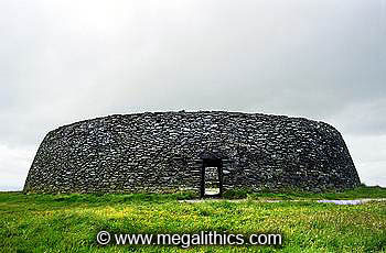
Situated 7km west of Derry, Grianan of Aileach (or Ailigh) is a impressive stone ringfort with surrounding earthworks perched on the summit of Greenan Mountain. The name Grianan of Aileach has been variously translated as "Stone Palace of the Sun", "Fortress of the Sun" and "Stone Temple of the Sun". Although heavily restored, there are no doubts as to the antiquity of the
site as it is one of only five Irish locations marked on Ptolemy of Alexandria's 2nd century map of the world.
The earthworks are the remains of a large hillfort that once enclosed the hill top, this is thought to have been built in the Late Bronze Age or Iron Age. The ramparts of the
hillfort have been eroded by time and only hints of their former stature remain, but recent accurate surveys show that there were two sets of ramparts, an inner and outer. Both of the ramparts were comprised of a pair of banks and the total area enclosed by the outer boundary is about 5 acres. A
hillfort with more than one enclosing wall is
termed as multivallate and of the 50 or so known Irish hillforts, Grianan of Aileach is the only multivallate example to be found in the north of country. About a third of Irish
hillforts have burial mounds or cairns within them
that predate the fort itself, Grianan of Aileach is no exception with the site of a destroyed "tumulus" only 40m SE of the cashel itself.
The stone ringfort also known as a caher or cashel, is thought to have been built in the early years AD and from the 5th to the 12th centuries it was the seat of the northern Ui Neill, the rulers of the Fifth of Ulster. For centuries the Northern Ui Neill alternated with the Southern Ui Neill, the rulers of the Fifth of Meath, for the Kingship of Teamhra (Tara), as an indicator of rule over all of Ireland. In later centuries the term Ard Ri, or High King superceded the Kingship of Tara as a term for the overall ruler of Ireland and this term is often applied to the Ui Neill.
According to the Irish Annals, Grianan of Aileach was destroyed in 1101 by Murtagh O'Brien, the
ruler of the Fifth of Munster, as a reprisal for the Ui Neill's destruction of his royal seat at Kincora
some thirteen years before. The account tells that O'Brien would settle for nothing less than complete destruction of the Ui Neill stronghold and ordered
each of his soldiers to carry away a stone from the fort as they departed.
Although the cashel looks very intact today, this is largely the result of restoration carried out between 1874 and 1879 by Dr. Walter Bernard (1), a
Derry antiquarian. The restored sections seem to include just about anything more than 1m above ground, so the fidelity of the upper walkways to the original layout can only be speculated upon.
The cashel is of well-fitted dry-stone construction and the the outer surface of the 5m high walls has a graceful curved, or battered, form.
There are excellent views from the fort across Lough Swilly, Lough Foyle and the
Inishowen Penninsular, it is claimed that on a clear day five of the nine
counties of Ulster can be seen from this viewpoint.
The interior of the structure today has a diameter of 23.6m N-S and is reached through a lintel-covered entrance passage 4.65m long and 1.86m high. The entrance passage originally had recesses let into each sidewall, although these have been filled in, their locations can still be traced. The interior of the walls has three terraces, or walkways, which are reached by several inset stairways.
Although the light was very poor during our visit it seemed to us that the outer
passage lintel had what looked like the legend "A.Watson" carved into
it in large letters - not original rock art we suspect.
Within the walls are two passages which extend almost to the entrance passage itself, they are accessed by two small doorways, one at the south and one at the NE. The southern passage is 0.5m wide and 0.85m high, it runs for about 20m, unfortunately the southern passage was just too tight for us to squeeze our
panoramic cameras in, so there is no VR coverage of this section, sorry. The northern passage is 0.6m wide and 1.4m high, a short section to the north is about 2.5m long and the main section runs south for about 8.6m where it ends at
a full-width seat-stone. The floors of both passages are liberally strewn with
modern litter including, as you will see from our VR panoramas, a complete deck
of playing cards! In addition to the wall passages a small drain opens at the NW and runs radially through the entire thickness of the wall.
A survey by Petrie (2) in 1835 mentions traces of a rectangular stone structure at the centre of the cashel and also of stone settings running from the cashel entrance to a gap in the inner earthwork banks where an "ancient road" approached the summit of the hill.
We could see no traces of either of these structures on our visit.
Grianan of Aileach, as with any ancient place in Ireland, has many folktales and legends associated with it. One legend tells of how the cashel was actually a place of sun-worship, the palace of hibernation of Graine, the Celtic Sun-Goddess. Another tells of how the fort was built by Dagda, the God- King of the Tuatha de Dannan to protect the grave of his son Aedh and that Nuada of the Silver Hand also has a royal burial place there. Finally, the sleeping warriors of the Ui Neill are said lie beneath the cashel, awaiting only for the call to arms to awake and spring into battle.
1. Bernard, W. PRIA Ser.2 Vol.1, 415-23
1870-9
2. Colby Col. Ord Surv Ireland, Co. Londonderry Vol.1, Dublin 1837