
|
|
More Pics |
|||
VR Panoramas |
|||||
Infrared |
|||||
3D Vision |
| NJ 48651 03477 (GPS 23min) | Diameter 17.0m (meas. SC.) |
| First Visited 1987 | No magnetic anomalies |
When we first visited Tomnaverie in 1987 the circle was in a sad state, the recumbent was tumbled forwards, both flankers were fallen and displaced, the eastern one teetering on the brink of a cliff caused by the quarrying that had threatened the monument on two sides. The quarrying had caused the loss of two circle stones and several others were fallen or missing, only four original stones still stood. The unmistakable remains of a ringcairn protruded through the undergrowth inside the circle, with what seemed to be both an inner and outer ring of kerbs being traceable.
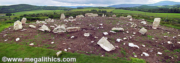
Our next visit was in 1999 and if anything, the circle looked even more despondent, the site was in the process of being excavated and was covered with bare
earth and ugly pieces of white fibre glass matting poking through everywhere
(see photo above). As we were to
discover in later years, this chrysalis of matting was to give birth to both a magnificently restored monument, and also
to an entirely new understanding of the genesis of the recumbent stone
circles (RSCs) themselves.
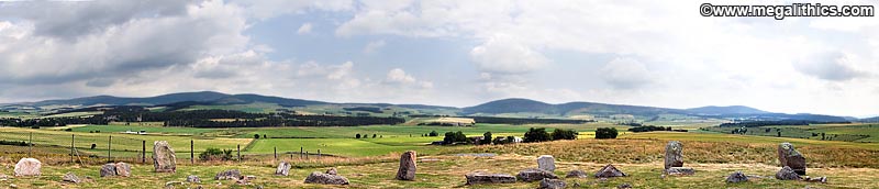
Even with the monument in such dilapidated states, its location was still guaranteed to take away breath of any visitor with megalithic interests. The circle is located on the crest of a small hillock that rises like a stage in the centre of a wide, flat area ringed with distant mountains. We have visited the majority of the
RSCs in Scotland, and this setting with its panoramic views must be one of the most dramatic. Having said that, it must be borne in mind that the deforested landscape
of modern times is very different to the one the monument was built in.
Antiquarian Accounts
The first mention of Tomnaverie we could find was in the Old Statistical Account of Scotland in 1792 where the minister of Coull parish described it as "only a few large stones, some upright, some
fallen down, without any appearance of figures or inscription" (1). He believed the stones to be "the remains of a Druidical temple" and quoted the name of the place as "Tamnavric, which signifies the Hill of Worship".
The New Statisical Account, has two mentions of the monument, the first is by the Rev.W.Campbell
(2) who described it as "One of those Circles of Stones standing upright, so common in Britain, and called Druidical Circles, may be seen on a small hill called Tom-na-hivrigh, or the Hill of Worship or Justice." The second authors, the Revs. Andrew and
Watson (3), were obviously more impressed by the monument and give more detail of the site, "distinct remains of a distinguished Druidical temple, containing two Circles formed of large erect stones at short intervals, from 4 to 5 feet in height, 3 broad, and 2 feet thick."
The description of two circles is repeated by Dr.John Stuart (4)
who described "the remains of two Circles of large erect stones."
We fervently hope that the two circles mentioned in the last two accounts are descriptions of the circle stones and those of the internal ringcairn, and not a second, now vanished circle. Antiquarian
accounts mention many more "Druidical temples" than exist today, for
instance, in Andrew and Watson's account above they mention three other
"Druidical temples" all just one mile from Tomnaverie, to the N, NE
and NW. The site at the north is probably Doune Hill, at the NE Knowhead, and at
the NW Melgum, Logie Coldstone or Waulkmill; the Melgum sites are ruins, one
stone remains at Waulkmill, and all of the others have completely disappeared,
many being destroyed within the last 200 years.
The last account in the antiquarian literature is, as usual for Scottish sites, that of the legendary Fred Coles (5) who gives his usual excellent description of the monument together with the plan and engraving of the circle shown below.
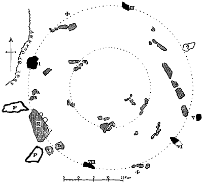 |
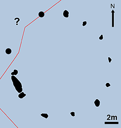
P = Pillar stone,
Fred's term for the flankers.
R = Recumbent stone. + = Missing stone. Hollow outlines are fallen stones. Solid fills are erect stone sections at ground level. Hatched fills (with the exception of the recumbent) show exposed ringcairn elements. The inner dotted circle is where Fred thought the inner kerbs of the ringcairn to be, he did not spot the ring of outer kerbs. |
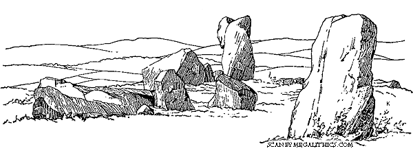
As usual, Fred's engraving shows the accuracy of small detail
typical of his work, comparing well with modern photographs. This view is from
the south, the prostrate eastern flanker lies far left with the fallen recumbent
in the centre behind the two smaller stones which are labeled "C" and
"D" in Fred's plan, the erect circle stone in the foreground is
"VIII" on the plan, and that in background "I". Fred was
very concerned about stone I as "the rock near its base had been quarried
away so close as to cause real uneasiness lest this fine Stone should be shaken
from its foothold." Unfortunately Fred's plea that it was "high time
that steps were taken to ensure the future safety of all the stones that are
left." fell of deaf ears, and exactly as he feared, the quarrying
eventually caused the loss of stone I. At the time of Fred's visit stone I was
the tallest still erect at the site, he gives its height as 1.70m and describes
it as "a rugged and rather top-heavy block". Although the stone has now vanished, we
can rely on Fred's engraving as an accurate depiction of its appearance.
Excavation
The most important excavation at Tomnaverie was directed by
Prof. Richard Bradley of Reading University (6) (7) (8)
and took place in two seasons
over 1999-2000. This excavation was to change the understanding of
recumbent stone circles completely, and in particular, the relationship of the
circle to the internal ringcairn that virtually all of these monuments contain. So
revolutionary were the findings at Tomnaverie that two further limited
excavations were carried out in 2001 at the Cothiemuir Wood and
Aikey Brae RSCs to determine if these monuments would produce similar findings.
General Description
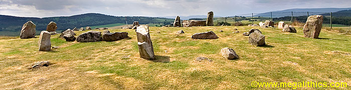
 Tomnaverie is situated on a small hillock about 6km NW of Aboyne.
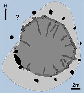
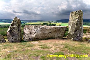
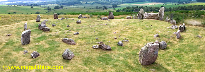
The monument is a Scottish Recumbent Stone Circle (RSC), comprising a huge (12.5
tons) recumbent stone at the SW framed by two flanking stones. There are presently
eight circle stones standing after the restoration that followed the 1999/2000 excavation,
plans at the site and Barnatt (9) both show
an original count of ten. The two stones that are missing today ( I and II in Fred's plan) are on the
western side and were both the victims of the quarry that has encroached upon the
circle; stone I and the socket of II were both extant during Fred's visit. While
drawing up the graphics for this web page we must admit that the spacing of the circle
stones and the sockets of the two missing stones did suggest to us that there
may have been a further stone between Fred's stones I and II. The area that the stone
would have occupied would most likely have been quarried away before Fred's
visit, so there would have been no socket to examine. The antiquarian accounts
before Fred do not mention stone numbers or positions, so there is no way to
tell if this stone ever existed, but if it did not, there would have been a
conspicuous gap at the NW, as our diagram (left) shows.
Tomnaverie is situated on a small hillock about 6km NW of Aboyne.
The monument is a Scottish Recumbent Stone Circle (RSC), comprising a huge (12.5
tons) recumbent stone at the SW framed by two flanking stones. There are presently
eight circle stones standing after the restoration that followed the 1999/2000 excavation,
plans at the site and Barnatt (9) both show
an original count of ten. The two stones that are missing today ( I and II in Fred's plan) are on the
western side and were both the victims of the quarry that has encroached upon the
circle; stone I and the socket of II were both extant during Fred's visit. While
drawing up the graphics for this web page we must admit that the spacing of the circle
stones and the sockets of the two missing stones did suggest to us that there
may have been a further stone between Fred's stones I and II. The area that the stone
would have occupied would most likely have been quarried away before Fred's
visit, so there would have been no socket to examine. The antiquarian accounts
before Fred do not mention stone numbers or positions, so there is no way to
tell if this stone ever existed, but if it did not, there would have been a
conspicuous gap at the NW, as our diagram (left) shows.
The circle stones and the flankers are graded in height towards the SW and the interior of the circle contains the remains of a ringcairn, both characteristic features of RSC's. The ringcairn was retained by an outer ring of kerbs, this was roughly 14.0m in diameter and also roughly concentric to the enclosing stone circle. We took some measurements at the newly restored ring, the recumbent was 3.2m long, stood 1.0m high and was 1.1m deep at its widest point. Both Barnatt (9) and Coles (5) report the recumbent to be composed of whinstone, and Fred reports that it is "computed" to weigh 12.5 tons. The eastern flanker was 2.20m long when prostrate and now stands 1.80m high, the western flanker was 2.84m long when exposed and now stands 1.90m tall, both the flankers and the circle stones that were erect during our 1999 visit were of red granite.
RSCs are monuments inextricably linked to the moon, their recumbent stones lie in the SSE to SW arc of the circle and usually correspond with the rising or setting of the moon at some prominent point during its 18.6 year cycle, the major and minor standstills in the cycle featuring prominently. The recumbent at Tomnaverie is unusual, it is positioned further west than any other surviving RSC. Viewed from the circle centre there is a window of 230.0-241.8 degrees above the recumbent, this aperture is centered on 235.5 degrees, which at this location is the setting point of the midsummer full moon at the lunar minor standstill.
Most of the facts above have been well known for many years,
it was to be the
excavation of 1999-2000 that would give us for the first time, a glimpse of how these
monuments were constructed and developed over time.
The Development of the Monument
 |
 |
The earliest feature detectable at the site was a cremation pyre, its area, identified by magnetic measurements, was found to contain a scatter of small cremated bone fragments. The first structural phase of the monument was the construction of a cairn, or platform, of stone rubble which leveled the site. The cairn was polygonal in shape and was encompassed by a kerb of massive slabs and glacial boulders, it was open at the centre, forming an enclosed space. The kerbs of cairn were in turn, surrounded by a a rubble bank which served to revet them, this bank was found to overlie a few sherds of Beaker pottery and was probably constructed around 2500-2400 cal BC. The cairn was found to have been terraced out towards the SW and contained radial divisions which linked it with the kerb, features which were to be mirrored in the structure of the later stone circle.
The stone circle was constructed next, enclosing the original cairn. The recumbent stone rested directly on the rubble bank that reveted the cairn kerbs, sockets for the flankers and circle stones were cut directly through the same material. The kerb of the cairn was demolished in the area around the recumbent and reconstructed to link onto it, the two pairs of small stones on either side of the recumbent (labelled A,B and C,D in Fred Cole's plan) being a result of this modification. As mentioned earlier, the internal cairn with its SW terracing may have exerted an influence on the siting of the circle elements, and several of the circle stones were found to be aligned with the radial divisions of the cairn.
The last activity detectable at the site was the digging of a cremation pit into the centre, this is thought to have occurred around 1000 cal BC.
Surveys associated with the 1999-2000 excavations revealed that the circle was not a monument in isolation, but was a deliberately sited, integral part of the prehistoric landscape. A rock art survey around the hill discovered a total of 29 cup-marked rocks, and it was found that their distribution was focused on the circle location. A fieldwalking exercise of cultivated land around the hill revealed the presence of six scatters of lithic artefacts of approximately the same age as the circle. The positions of these scatters have been interpreted to define the limits of settlement at the time of the circle's construction, and it appears from this that the circle was located at the very edge of the land that was settled then.
The discovery that ringcairn predated the circle construction completely changed ideas of how these monuments had evolved and were constructed. This finding was of such importance that further limited excavations were carried out at the RSCs of Cothiemuir Wood and Aikey Brae in 2001 to see if the same sequence of construction could be found at those monuments. Sure enough, both of these investigations returned similar findings.
Visiting the site
The restored circle is a truly beautiful site to visit, the circle is now neatly grassed over, the quarried area to the south has been filled, and there is a small car parking space available below the hill. The raised location allows for panoramic views in all directions, and there is also an information plaque which gives details of the circle and its history. Those with an interest in prehistory or megalithic monuments will need no coaxing to visit Tomnaverie, and for the casual visitor it is wonderful place for a stroll or a picnic.
Highly recommended!
Further Reading
Prof Richard Bradley has written a book about the investigations at Tomnaverie, "The Moon and the Bonfire", published by the Society of Antiquaries of Scotland in 2005, ISBN 0 903 903 33 4.
Acknowledgments
Our sincere thanks to the Society of Antiquaries of Scotland for permission to use illustrations and extracts from their Proceedings.
1. Old Statistical Account of Scotland, 3,
p201, 1791-99.
2. New Statistical Account of Scotland, 12, p958, 1842.
3. New Statistical Account of Scotland, 12, p842, 1842.
4. Proceedings of the Society of Antiquaries of Scotland, 1, p260, 1854.
5. Proceedings of the Society of Antiquaries of Scotland, 39, p208-13, 1904-5.
6. Bradley R., Discovery and Excavation in Scotland, p7-8 1999.
7. Bradley R., Discovery and Excavation in Scotland, 1, p9 2000.
8. Bradley R., Antiquity, 74, p465-66, 2000.
9. Barnatt J., Stone Circles of Britain, B.A.R. 215(ii)
Site 6:95, p.304,1989, Oxford